Map dashboard
The Map dashboard displays a graphical rendition of records, including addresses, parcels, inspections, and more. From this dashboard, you can view records, create records, search for records, and attach assets to records.
The following options appear on the right side toolbar and the bottom of the map.
| Options | Icon | Description |
|---|---|---|
| Zoom |

|
Allows you to zoom in and out on the map. You can also zoom in by double-clicking, or zoom in and out by using a mouse wheel. Pan the map by clicking and holding down your mouse button on a spot and dragging the mouse. |
| Home |

|
Displays the default view, or the initial area shown on the map. Note: The default view is configured by the administrator of the map service provider. |
| Locate me |

|
Finds your current location according to your browser. See Locate me for more information. |
| Basemap |

|
Allows you to choose the type of basemap. |
| Layers |

|
Allows you to view GIS map layers. See Map layers for more information. |
| Measure |

|
Allows you to select the unit of measure for an area, distance, or the geographic longitude and latitude location to measure on the map. |
| Draw |

|
Allows you to add a line, shape, or text to the map. See Draw option for more information |

|
Allows you to print the map to a PDF or another selected format. See Print a map for more information. | |
| MultiSelect |

|
Allows you to select a specific area on the map by drawing a line or shape. See MultiSelect tool for more information. |
| Heat map | n/a | By default, locations are plotted on the map with pins. Select Heat map to show locations using gradient hotspots. Select Heat map again to return to pin view. |
| Map scale | n/a | Shows the ratio of measurement on a map compared to the actual distance. The scale and unit of measurement are provided by the map service. |
| Map legend | n/a | Shows an explanation of the map symbols as provided by the map service. |
The map dashboard provides various ways to select GIS objects or features on the map.(See Select single and multiple GIS objects on a map for more information.) After selecting multiple GIS objects on the map, the Contents panel lists related parcels, assets, and GIS objects that are associated with the selected GIS objects on the map.
Example screen of contents panel:
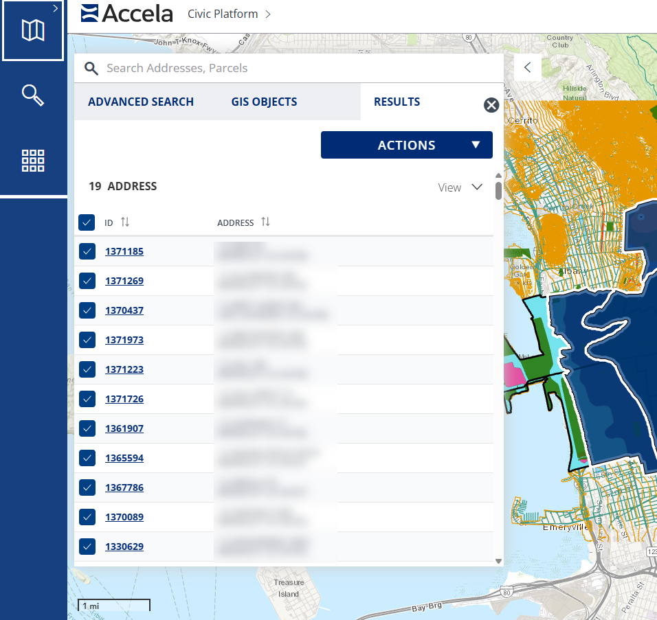
The Contents panel has three available tabs:
- Advanced search tab — Allows you to locate objects (such as addresses, assets, parcels, inspections, records, and others) and GIS features. The results are listed on the Results tab.
- GIS objects tab — Lists the GIS objects or features that are selected on the map. The GIS objects are listed by the map layer they belong to (such as, Parcels, Records, and others). As items are selected or deselected from the map, the lists of related parcels, assets, and records refresh on the Results tab.
- Results tab — Lists the parcels, assets, and transactional records that are associated with the selected GIS objects on the map. This tab is refreshed when you select or deselect items on the GIS objects tab or when you select more objects on the map.
Notes:
-
Search results on the map dashboard are accumulated. Recent search results are appended to the existing search results and can be selected.
-
You can hover your cursor on an item listed in the tabs to highlight it on the map.
-
You can also use the Actions menu to perform various actions on the listed items.
When you select multiple objects on the Map dashboard, a panel displays listing the selected objects, grouped by type. You can select a type to see a detailed list of objects of that type, and you can select an object to see details about that object.
Navigation arrows
You can return to a previous view or close the panel:
- The left-facing arrow
 returns you to a previous view.
 - The x in the upper right corner closes the panel.