Map layers
A map view consists of multiple layers from a map service or a mash-up of multiple map service providers.
Depending on the permission settings defined for the user group you belong to, you can customize the visibility of the map layers according to your workflow needs.
To access the map layers option
-
From the Map dashboard, select the Layers option
 from the toolbar on the right.
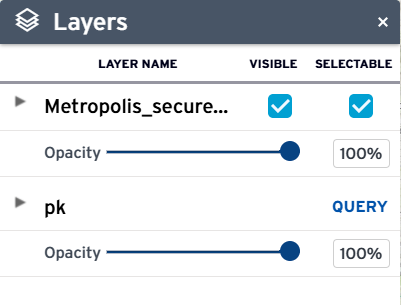
The Layers option allows you to set the visible and selectable attributes of the map layers. It displays the various map services and layers on the map. When you select the Layersoption for the first time, the option displays the map services you have access to, and whether those services are visible or selectable.
Note: If a map service name is truncated because it is too long, hover your mouse over the map service name to see its full name.
On the list of map services, you can expand a map service to see its map layers. The Layers option allows you to control their map view by setting the visible or selectable attributes of the map layers. This is especially helpful when selecting or editing multiple GIS objects on map service mash-ups.
Note: If there are parcels and assets associated with the selected GIS objects, they will be listed on the Records tab of the map Contents panel.
On the Layers option, you can:
-
Expand or collapse the hierarchical list of map services and map layers.
-
Toggle the Visible option to show or hide a map service or layer.
-
The current visibility of a map layer depends on its configured visibility scale on the map service.
If the map is not currently zoomed at the configured scale dependency, the map layer on the Layers option is disabled. When the you zoom into a visible scale, the map layer along with the Visible and Selectable options become enabled.
-
Deselecting the Visible option for a map service hides all of its map layers. However, changing the Visible option for a map service (or a parent map layer) does not change the Visible option of the children map layers.
The Visible option settings for children map layers persist to allow you to easily toggle the setting at the parent level and adjust it at the individual level only if necessary.
Example: If a map service has at least 20 layers, you can toggle the visibility at the map service level and avoid having to deselect or reselect at least 20 options. -
Deselecting the Visible option automatically deselects the Selectable option. A map service or layer is selectable only if it is visible.
-
Selecting the Visible option again does not automatically reselect the Selectable option because a visible layer is not necessarily selectable. You must explicitly make a map layer selectable.
-
-
Toggle the Selectable option to allow or disallow GIS object selection on the map service or layer.
-
Deselecting the Selectable option for a map service deselects all of its map layers. However, changing the Selectable option for a map service (or a parent map layer) does not change the Selectable options of the children map layers.
The Selectable option settings for children map layers persist to allow you to easily toggle the setting at the parent level and adjust it at the individual level only if necessary. (Let's say a map service has at least 20 layers, you can just toggle the selectable at the map service level and avoid having to deselect or reselect at least 20 options.)
-
If the Visible option is not selected or a map layer is not visible at the current zoom level, the Selectable option is disabled.
-
-
Move the Opacity slider under a map service to adjust its opacity (100%) or transparency (0%).
-
Run a Query if a map service contains layers that have been configured with a dynamic theme query. The following example shows the Query link for the Permits map service containing dynamic theme queries for the Buildings objects, Open Permits, and Street objects map layers:
The GIS administrator configures the map service permissions and the initial settings of the Visible and Selectable attributes for the default or any named GIS user group. Contact your agency administrator with questions.
The layer editing tool opens a selected map layer in an edit layer session during which you can add or update GIS object drawings and attributes.
The layer editing tool icon  appears next to the layer name if the map is zoomed at a visible scale, and if you have permissions to edit the map layer. The following sample Layers option shows next to the
Parks map layer, which is visible and editable by you, if you are logged-in.
appears next to the layer name if the map is zoomed at a visible scale, and if you have permissions to edit the map layer. The following sample Layers option shows next to the
Parks map layer, which is visible and editable by you, if you are logged-in.
To edit a layer, click the icon next to the map layer. The edit layer session displays the Edit layer toolbar, Layers option, and Edit GIS object panel.
The edit layer session disables the search box, selection tool, zoom control, and the other map options. The edit layer session also resets the GIS objects panel. After you stop an edit layer session, the GIS objects panel shows only the new or updated GIS object(s) on the map layer that was just edited. This GIS objects panel (that is displayed after an edit layer session ends) does not show GIS objects that were previously selected before you started the edit layer session.